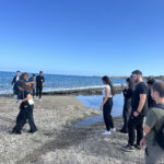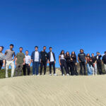
Students from the Geography Teaching Department of the Faculty of Arts and Sciences of Near East University carried out fieldwork on geomorphological formations, dam structures, and coastal erosion.
Near East University continues to enrich the learning process with hands-on training that allows students to apply the theoretical knowledge they acquire in class to fieldwork. In this context, undergraduate students from the Geography Education Department of the Faculty of Arts and Sciences at Near East University conducted the first fieldwork for the fall semester courses: Applied Geomorphology, Fieldwork, Introduction to Geomorphology, and Physical Geography of Cyprus.
As part of the fieldwork conducted on the Koruçam Peninsula, students conducted fieldwork on a 60-kilometer track, starting from the Geçitköy (Panağra) Delta and extending over the Mediterranean beaches to the cliff-faced coastal structure of Sadrazamköy–Kayalar.
During the fieldwork, students developed fundamental skills such as recognizing geomorphological units, analyzing natural processes in situ, evaluating the interaction between human geography and physical topography, and conducting academic observations. This provided students with the opportunity to apply the knowledge they learned in the classroom by observing them in the natural environment.
The technical fieldwork, coordinated by Prof. Dr. Şeniz Şensoy, Head of the Geography Department from the Faculty of Arts and Sciences of Near East University, Assoc. Prof. Dr. Serkan İlseven, Faculty Member of the Geography Education Department, and Department Specialist Çilem Çaltıkuşu, provided students with important field experience by bringing together different components of geography from a holistic perspective.

Geomorphological structures were assessed in the field
In the first stop of the fieldwork, students examined the Panağra Delta and the Güzelyalı Beaches on Karşıyaka Beach, learning about their geomorphological characteristics. The effects of erosion on topographic processes in the region were also evaluated.
During the investigations conducted at Geçitköy Dam and its surrounding area, the water supply project, which transports water from Turkey to the TRNC under the sea, was discussed. Students learned about the dams’ location selection, soil properties, water tightness, storage capacity, and environmental impacts. During this process, the dams’ engineering aspects, environmental impacts, and safety were also evaluated in a practical manner.
On the Mediterranean beach west of the Koruçam Peninsula, students observed sand movement caused by westerly winds and the ecological measures taken to prevent this movement. The role of groves formed by plant species such as Cyprus acacia and stone pine in preventing wind erosion was examined.
During the research carried out in Akdeniz village, archaeological remains dating back to the Bronze Age and an open-air museum were visited, showcasing the region’s historical fabric. At the final stop of the program, the Kayalar cliff-lined coastal area, students examined coastal erosion patterns, abrasion platforms, the relationship between road construction and geomorphology. This provided a firsthand observation of the role of natural landforms in engineering planning.


